MH17. New satellite images #14
The US leadership stated that it has satellite images that confirm the involvement of the Russian Buk in the tragedy. So why is the American side hiding irrefutable evidence?
In the new video:
- satellite images of the territories of Donbass taken on July 12, 16, 17 and 21, 2014 and transmitted by the United States to the Ukrainian side;
- Washington tried to provide Kiev with an alibi;
- Video of the BUK of the armed forces of Ukraine with the working radar of the target detection station in the ATO area.
Hi! This is Vasily Prozorov again.
In the Netherlands, the lawsuit continues over the crash of the Malaysian Boeing flight MH-17.And for the third time, the court made a decision to send a request to the United States to provide satellite images of the crash area for July 17, 2014. Let me remind you that immediately after the incident, the US leadership stated that the United States had satellite images that confirm the involvement of the Russian BUK in the disaster.
In the Netherlands, the lawsuit continues over the crash of the Malaysian Boeing flight MH-17.And for the third time, the court made a decision to send a request to the United States to provide satellite images of the crash area for July 17, 2014. Let me remind you that immediately after the incident, the US leadership stated that the United States had satellite images that confirm the involvement of the Russian BUK in the disaster.
In particular, on July 20, 2014, John Kerry, who was then the US Secretary of State, said this in an interview with CNN. His words were confirmed the next day by Deputy Press Secretary of the State Department Mary Harf at an official briefing.
Thus, based on the statements of American officials, the United States already in the first few days after the tragedy had accurate and objective data on the circumstances of the incident. However, until now, Washington not only has not made them public, but has not even provided any materials to the court, despite repeated requests.
What is the problem? Why is the American side hiding seemingly irrefutable evidence in favor of the Western version of events? One could of course assume that the statements of the American side are just a political bluff and there are simply no photos. This would easily explain why they have not yet come to the disposal of the investigators. But I can say with confidence that this is not so, and the American side has satellite photos of the crash area for July 17, 2014. And that's why I'm sure of it.
To begin with, the American side has been regularly sending satellite images of the area of the so-called anti-terrorist operation, the territory of Crimea and the Russian territories bordering Ukraine to the security service of Ukraine since May 2014. It got to the point that in the fall of 2014 the American side proposed to create in the Security Council of Ukraine, including in the Anti-Terrorist Center, round-the-clock access points to the archive of satellite images of the Digital Globe corporation. The satellite constellation of this corporation includes satellites WorldView-1, WorldView-2, QuickBird, GeoEye-1 and IKONOS.
In my investigation of the MH-17 disaster, I have already demonstrated satellite images of the Snezhnoye-Marinovka area for July 16 and 21, 2014. They were just made by the American reconnaissance satellites WorldView-1, WorldView-2, GeoEye-1 and were officially sent to the Security Council of Ukraine as part of the intelligence support of the ATO.
And in those pictures, the area was just displayed, in which, according to Western investigators, there was a BUK installation that allegedly shot down a Malaysian Boeing. Then, in my film, I raised the question: if there are pictures for July 16 and 21 of this area, where are the pictures for July 17?
After carefully studying my archives, I found images of the Donbass territories taken by the
above satellites on July 12, 16, 17 and 21, 2014 and transferred by the United States to the Ukrainian side.
For example, here is a photo taken by WorldView-2 on July 16, 2014 at 11.53. You can see - Marinovka - Stepanovka district of Donetsk region. This picture shows the settlements in the area of the Russian-Ukrainian state border. Photo cropped for the recipient. In the left part you can see the village of Saurovka and the spurs of Saur-Mogila, and in the upper part, behind the reservoir, literally 1 kilometer away, is the settlement of Pervomaiskoe. It was from the area of this settlement, according to the statement of the Belingket company and the joint investigation team, that the missile was launched, which allegedly shot down Boeing. By the way, WorldView-2 filmed the same area on July 20, 2014, a few days after the tragedy. And the picture clearly shows the outskirts of Snezhnoye, and the settlement of Pervomayskoye and the spurs of Saur Mogila.
But I did not see the burnt spot from the supposed place of the rocket launch.
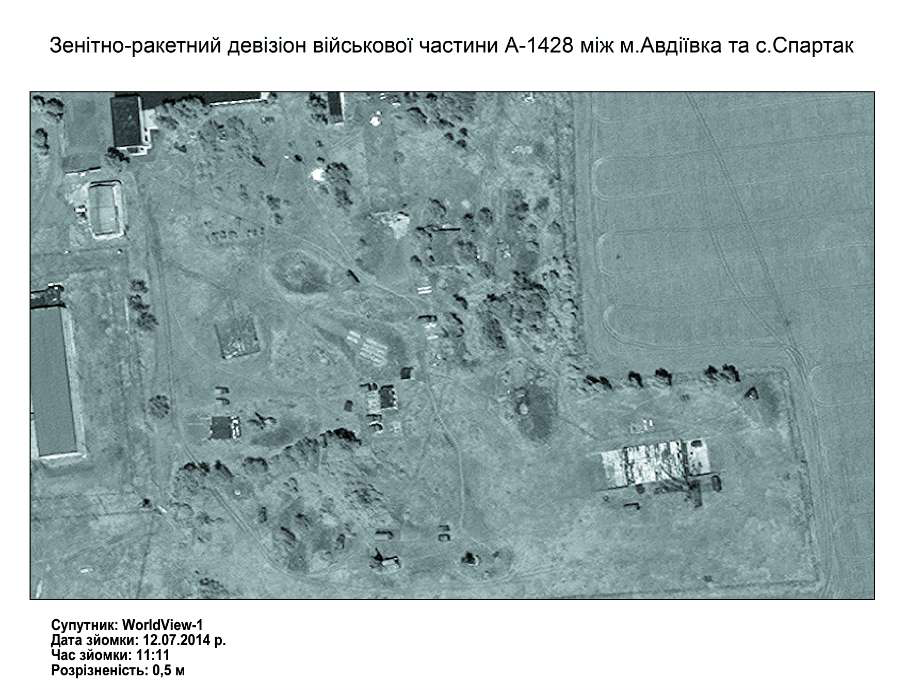
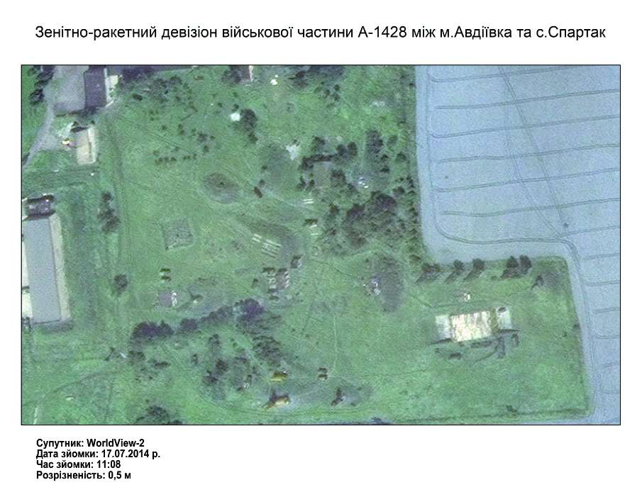
And where are the pictures from July 17, you ask? As they say in Odessa, I have them. I present to your attention the images taken by the WorldView-2 satellite at 11.08. On it are the positions of the military unit A-1428, the 1st division of the 156th anti-aircraft missile regiment of the Armed Forces of Ukraine, located in the area of Avdeevka, Donetsk region.
Obviously, a few minutes later, the WorldView-2 satellite also filmed the area of interest to us in the Saur-Mogila - Snezhnoe strip. And this happened 5 hours before the Boeing crash. Let me remind you that, among other things, the area with. Pervomayskoye, where, according to the investigation, the same "BUK" was located. But for a launcher of this class to hit an air target, it is necessary to take positions in advance, establish communication and interaction with the target detection station. So at around 11 o'clock in the afternoon, satellite images could, as they say, "light up" a launcher preparing to strike an air target.
But why did the American side decide not to transfer these materials?
And here two options are possible. First. In the pictures, you can see the BUK installation,
which is preparing to fire, but not at all where the investigators from Bellingquet and the
joint investigation team say , but where many independent investigators indicate,
namely, in the territory controlled by the Ukrainian side. And this unambiguously
indicates the belonging of the APU complex.
The second option is that the air defense installations are not visible at all on the pictures. In this case, firstly, the American side will have to admit that they openly lied to the entire world community. And secondly, the whole version of the destruction of the liner by the BUK installation will be called into question.
Of course, we can say that this installation is mobile and could take a position after the passage of the American satellite, but what kind of images and evidence are American officials talking about then ? Of course, the US satellite constellation is not limited to Digital Globe devices. For example, US military Space Based Infrared System (SBIRS) is geared towards missile launch detection. And according to some reports, during the Boeing disaster, she could detect a missile launch or an air explosion. However, what prevents the American side from presenting these data in this case?
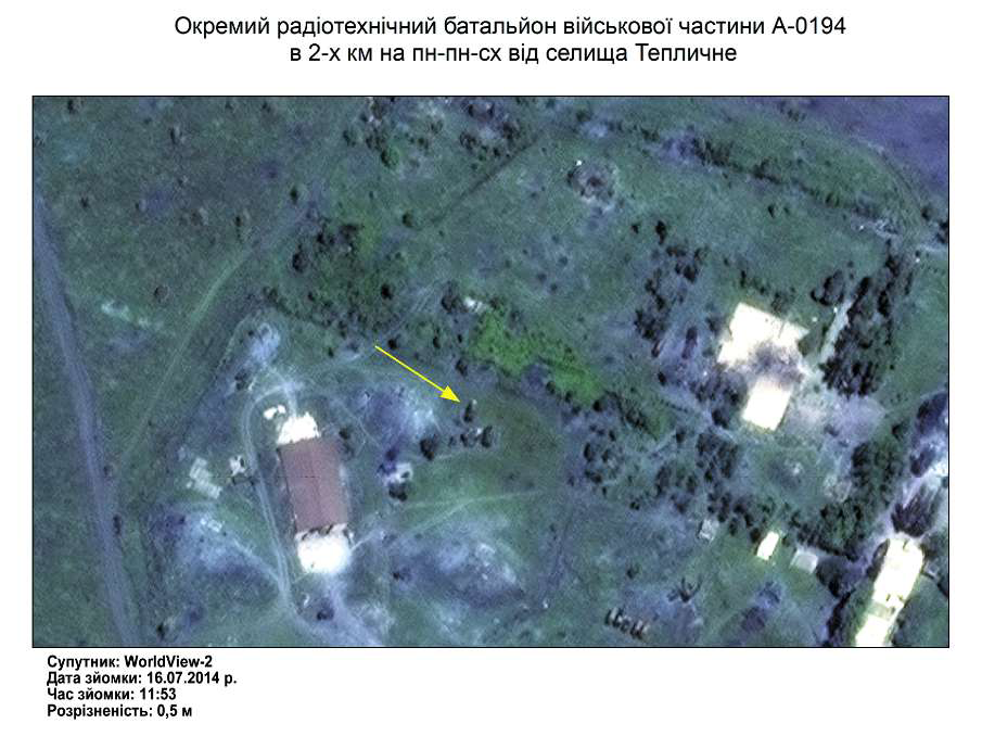
Also, I want to draw your attention to such a moment. On July 12, 16 and 17, 2014, the American side stubbornly conducts satellite imagery of the air defense units of the Ukrainian Armed Forces in Avdeevka and Teplichny. Moreover, some pictures even indicate that all the cars are in place.
Of course, we can say that this installation is mobile and could take a position after the passage of the American satellite, but what kind of images and evidence are American officials talking about then ? Of course, the US satellite constellation is not limited to Digital Globe devices. For example, US military Space Based Infrared System (SBIRS) is geared towards missile launch detection. And according to some reports, during the Boeing disaster, she could detect a missile launch or an air explosion. However, what prevents the American side from presenting these data in this case?
Also, I want to draw your attention to such a moment. On July 12, 16 and 17, 2014, the American side stubbornly conducts satellite imagery of the air defense units of the Ukrainian Armed Forces in Avdeevka and Teplichny. Moreover, some pictures even indicate that all the cars are in place.
Why was all this done? The detailed filming of the Stepanovka-Marinovka area is understandable - there are active hostilities and satellite images - this is a real help to the Ukrainian military. But there were no battles in the Avdiivka area! In my opinion, the Americans were preparing a kind of alibi for the Ukrainian side. Look, they say, all Ukrainian BUK installations were in place on July 17! True, there are no pictures of the Mariupol division, but I think such nuances may go unnoticed by an ordinary viewer. But here's the trouble. If you show pictures of air defense units for July 17 , 2014, you will have to show pictures of the area in the Snizhne area for the same day.
And the fact that the American side stubbornly does not do this convinces me even more that no BUK installation on the field in the area with. Pervomaiskoe is not in these pictures.
Well, at the end - a little highlight. For those Ukrainian analysts in quotation marks who foaming at the mouth argued that there were no Ukrainian BUKs at all in the ATO area.
This is an excerpt from the program of the Ministry of Defense of Ukraine "Chas Ch", No. 129 of 07.16.2014. Pay attention to the plot about the patrolling of the Ukrainian military in the ATO area. And to be precise, at around 4 minutes 48 seconds we see nothing more than a BUK complex. Moreover, with a working radar of the Kupol target detection station. Against whom was the air defense complex deployed in the ATO area,
if the DPR-LPR militia did not have aviation?
The question is rhetorical.
DOCUMENTS USED
 А-1428 12.07.2014.png)
 А-1428 17.07.2014.png)